

Educating the Public
Another way WHIPS accomplishes its resource conservation is by providing information to local and state government officials about the unique natural resources of the Whipstock Hill area and promoting natural resource preservation. Examples of this area of activity include the following:
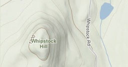
~ We conducted a project to inventory and map the Whipstock Wetlands, an extensive area of Class II wetlands along the base of Whipstock Hill in West Bennington. In this project, we worked with a wetlands biologist from the Vermont Wetlands Office (Agency of Natural Resources), a cartographer from the Bennington County Regional Commission, and in cooperation with the Vermont Agency of Transportation, an affected landowner. The Vermont Significant Wetland Inventory (VSWI) map indicated that the wetlands were approximately 8 acres in size. Instead, we demonstrated that the actual area of wetland was approximately 60 acres. We submitted our findings to the Vermont Water Resources Board, and as a result of our efforts, the VSWI map was officially amended. We then successfully petitioned the Bennington Planning Commission to add the Whipstock Wetlands to the Bennington Town Plan as a Significant Natural Area.
View the wetlands map
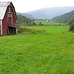
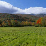
~ We mapped the scenic viewsheds along Vermont Route 9. In this project, we worked with a cartographer from the Bennington County Regional Commission to photograph and document the most scenic focal points along the gateway into Bennington.
One of the outcomes of this project was an increased awareness of the parcels of farm and wood land that were of a high priority to preserve.
The map has been an important tool for prioritizing WHIPS’s financial assistance to land conservation projects undertaken by other conservation organizations (see below).
It has also been an important tool for local fundraising for those projects, in addition to raising local appreciation for the beauty of the working landscapes along the gateway.
View the (West End Conservation Initiative map.)

~ We submitted written comments and testified at public hearings before the Town of Bennington’s Planning Commission and Select Board in support of land use regulations aimed at preserving the West End’s working lands. We also supported new construction design standards and an Agricultural Overlay district that were intended to preserve the West End’s rural character. These items were subsequently included in the Bennington Town Plan, Subdivision Bylaw and Zoning Bylaw.
~ We helped organize public support for a law banning new billboards in the Town of Hoosick.
~ We helped organize public support for the Land Use Law adopted by the Town of Hoosick. We specifically advocated for an Agricultural/Residential zone for the East Hoosick neighborhood that includes Whipstock Hill. This land use designation will help protect this predominantly rural, agricultural and scenic neighborhood from incompatible development.